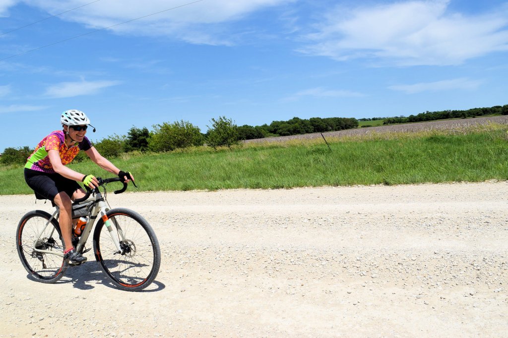
All routes are tentative and subject to change depending on gravel conditions, construction, etc. Stay tuned to our Facebook page and website for any additional changes to the routes. Click on the links in the titles to see the full Ride with GPS routes.
Saturday
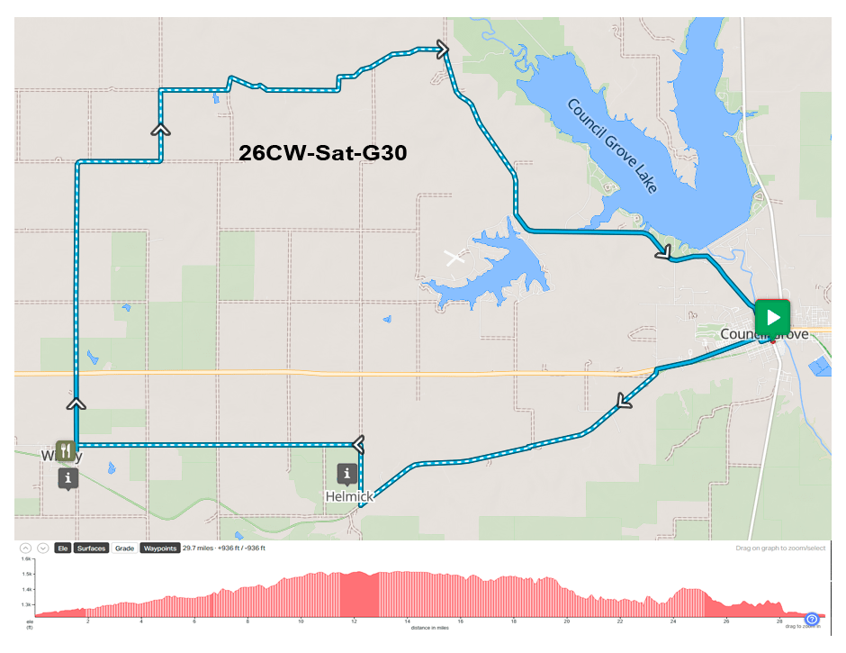
Route 1 – Gravel Short – Click Here for Full Route
Total Miles: 30
Elevation: +947/-947 ft
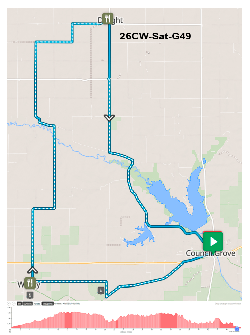
Route 2 – Gravel Long – Click Here for Full Route
Total Miles: 49
Elevation: +1655/-1655 ft
Notes on Saturday Gravel Routes
Saturday gravel offers two routes, a long route of 49 miles and a shorter route of 30 miles. Both will cross the old Katy rail line at some point.
Both routes ride west out of Council Grove to take Helmick Road along the Santa Fe Trail west to 1400 Rd. Going north you come across a Santa Fe Trail Ruts sign where you can see a nice cut in the ditch where wagon wheels dug into the bank.
Going west on V Rd. will take you into Wilsey. This will be the SAG for both road and gravel riders.
Heading north out of Wilsey you stay on 1800 Rd. then east on Q Ave. for a mile and then north on 1700 Rd. The routes split the next mile at P Ave and 1700 Rd. Short riders go east on P Ave. Long riders continue north on 1700 Rd. and on through the semi ghost town of Parkerville.
Long Route – 49 Miles
Long riders keep going north on 1700 Rd to Parkerville. Continuing out of Parkerville you will be on pavement until you turn north on 1800 Rd. After crossing Hwy 4, this takes you to D Ave. From there you go east for 2 miles and pick up 1600 Rd. going north to C Ave., putting you back on pavement going east into Dwight. The SAG for both road and gravel riders is at the Event Center in Dwight on 8th St.
Leaving Dwight, the route goes south on Hwy 4 for about 3 miles and connects with 1400 Rd. This eventually hooks up with Parkerville Rd. going east for a little over a mile to the Church at Kelso. Turning south on Kelso Rd. will take you back to Council Grove.
Short Route – 30 Miles
At the intersection of 1700 Rd. and P Ave. the short route goes east on P Ave. for about 4 miles until connecting with Kelso Rd. and turning south to head back to Council Grove. This is a nice little section with good views of the surrounding Flint Hills.
History Along the Routes
If you have the time after the SAG in Wilsey, take 1800 Rd. south of town for about a mile and you’ll come across another Santa Fe Trail Ruts sign. The ruts are on the west side of the road, and this is probably one of the easiest places to see Santa Fe Trail Ruts. The visual description of the ruts is that of “swales” on the land – almost as if it was a rolling sea. Swales are usually lined up 8 or 9 feet wide and very deep. Wagon masters would use double and triple teams of oxen and mules for the trip across the plains.
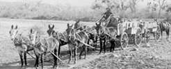
The Santa Fe Trail was more of a highway for heavy wagons carrying goods from East to West and back again with large oxen or mule teams doing the work.
Think of these as the “big rigs” of their day carrying commerce. Even when railroads first started to cross the area, more tonnage of goods could still be transported by wagon and team.
KATY Railroad
Along with the opportunity to see Santa Fe Trail ruts, both routes roughly follow the old MKT Railway route that originally ran from Galveston, TX to Junction City, KS.
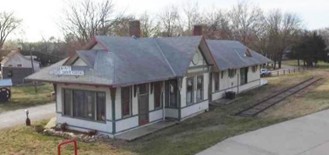
The historic Missouri-Kansas-Texas (Katy) Railroad depot in Council Grove, built around the 1880s, is one of only two remaining original M-K-T (Missouri–Kansas–Texas Railroad) depots in Kansas.
In the 1890s, the MKT was commonly referred to as “the K-T”, because for a time it was the Kansas–Texas division of the Missouri Pacific Railroad and “KT” was its abbreviation in timetables as well as its stock exchange symbol. This soon evolved into the nickname “the Katy.”
Council Grove sat on what was referred to as the Neosho Division because it followed the Neosho River north through Emporia and on to the terminus of Junction City.
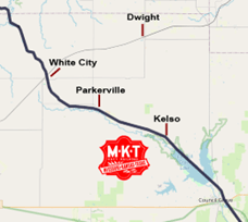
One purpose of this extension was to connect Fort Riley with Fort Scott to the south. There were several stops going north out of Council Grove including Kelso and Parkerville. The M-K-T rail line through Council Grove was abandoned in 1957 and the section just north of town was submerged in the 1960s when the reservoir dam was built by the Corps of Engineers.
More information including rail route maps here: https://katyrailroad.org/map/
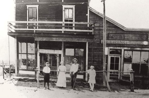
Parkerville
Founded in 1870 by Santa Fe Trail freighter Charles G. Parker along the KATY Railroad, the town was incorporated in 1871 and became the second incorporated town in Morris County. That same year, Parkerville challenged Council Grove for the county seat, but lost the election 413 to 899, with both sides allegedly using questionable voting tactics.
Both communities imported potential voters by giving hordes of transients enough work to last them through the election. In that contest, “there was nearly a vote for every man, woman and child living in Morris County,” according to Mrs. Frank Prescott’s 1936 “History of Parkerville” in the White City Register.
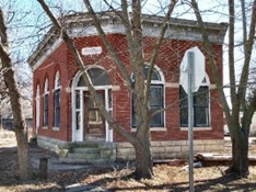
Like the other small farming communities of Morris County, Parkerville thrived through the late 1870s into the mid-20th century with a grade and high school, bank, newspaper, law offices, a veterinarian, grocery store, and other businesses. The bank closed during the Great Depression in 1931. The last train went through in 1950, and the evidence it ever was a whistle stop was gone by 1963.
Kelso
Kelso was a small unincorporated community in the Neosho Township of Morris County and is now recognized as an extinct town. Situated along the Neosho River, it operated as a station on the (MKT) Missouri, Kansas & Texas Railroad from 1881 to 1942. Today, it is a rural, unincorporated area northwest of Council Grove.
In 1910, it had about a dozen businesses and a population of 76. The end of the KATY in the 50s undoubtedly led to the decline of the settlement.
Dwight
The SAG stop in Dwight will be at the Event Center on 8th St. which is home to Pink Gravel. Pink Gravel combines awareness of breast cancer with the love of gravel riding in the Flint Hills. More information here: https://www.pinkgravel.com/.

Funds that are raised go to support grant assistance helping to cover medical bills, travel, and lodging for breast cancer patients and survivors in Kansas counties including Lyon, Chase, Coffey, Greenwood, Morris, Osage, Riley, and Wabaunsee.
In 1887, Dwight was founded by investors looking to take advantage of the expansion of the Rock Island System west from Topeka by the Chicago, Kansas, and Nebraska Railway Co. Land was purchased for platting the town which was named after Dwight Rathbone, who donated land for the Dwight Methodist Episcopal Church.
A post office was established in Dwight on March 19, 1887. Dwight was incorporated as a city in 1903.
The Chicago, Kansas and Nebraska Railway was foreclosed in 1891 and taken over by the Chicago, Rock Island and Pacific Railway, which shut down in 1980. It then reorganized as the Oklahoma, Kansas and Texas Railroad, merged in 1988 with Missouri Pacific Railroad, then merged again in 1997 with the Union Pacific Railroad. Most locals still refer to this still active railroad as the “Rock Island.”
Sunday
Gravel Route – Click Here for Full Route
Total Miles: 74
Elevation: +2702/-2702 ft
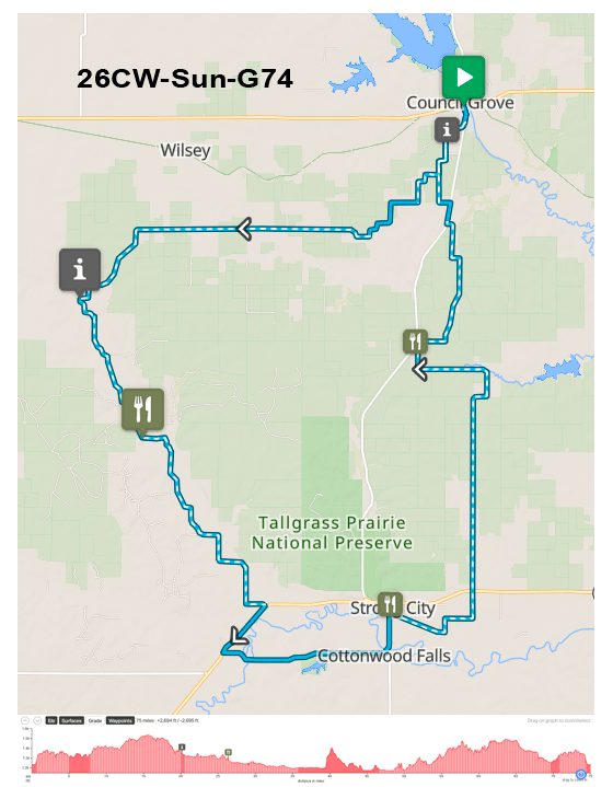
Notes on Sunday Gravel Route
The gravel route for Sunday goes southwest from Council Grove to Diamond Creek Rd. then turning south. There will be a SAG at about mile 25 near the corner of the now defunct settlement of Hymer. Keep an eye out for the Buffalo!
Continuing south on Diamond Creek Rd brings you to Elmdale at Hwy 50 and then on into Cottonwood Falls via paved county road and lunch in Strong City at about mile 45.
The return is east out of Strong City on Old 50 (gravel), then north on V Rd to the SAG at Hwy 177 and DD Ave at about mile 63. From there it’s 850 Rd. north to 4 Mile Rd and on into Council Grove. One caveat here – 850 Rd goes through open ranch land and if the owners close the gate, then you would have to take Hwy 177 to 4 Mile Rd.
But . . . you don’t have to do all gravel!
You can mix and match after Strong City. Either take Hwy 177 out of Strong City back to Council Grove or jump back on pavement after the SAG at Hwy 177 & DD Ave.
History Along the Route

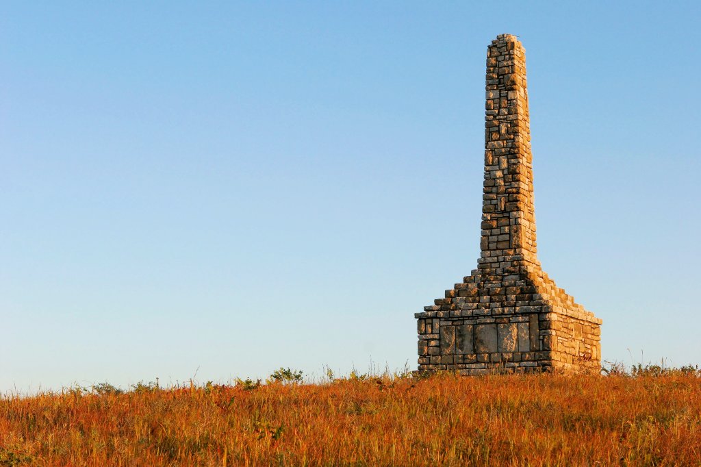
Just as you are leaving Council Grove on 900 Rd. you come across the Father Padilla Monument. You can see the monument on the hill and there is a roadside sign that tells the tale of how Father Padilla became the “the first American Martyr” in 1542.
Diamond Springs
After reaching 4 Mile Rd. and then taking Z Ave. west, the road eventually curves around to the south and becomes Bb Rd. At the intersection of Bb Rd. and Diamond Creek Rd. is the site of what was once the settlement of Diamond Springs.
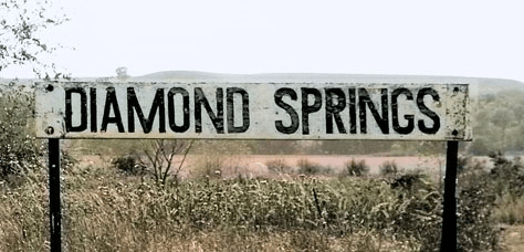
Diamond Spring (as it was originally known) was one of the most widely known camping sites along the Santa Fe Trail. Located sixteen miles west of Council Grove it had the three necessities for overland travelers: a plentiful supply of good water, grass, and timber. At the time this was primarily open grassland without the brush that you see today.
The spring was discovered on August 11, 1825, by “Old Ben Jones,” a hunter with the U.S. Surveying Expedition. Of course, this watering hole was well known by native people before then. According to the report of George C. Sibley, one of the three commissioners appointed by the President to mark the road from Missouri to Santa Fe, he had named it “The Diamond of the Plain” and carved the name on a nearby elm tree during a return visit in 1827.
A mail station was established in 1850 by the Waldo Hall Company and the organization was given license to trade with the Kaw Indians. This allowed employees to stay in Indian Territory before the opening of the area for settlement by the Kansas-Nebraska Act of 1854. This was no small operation. The station consisted of two large stone buildings, one to serve as a hotel, restaurant, and saloon; the other to serve as a warehouse and store. In addition, a blacksmith shop, a number of corrals, and a full complement of out buildings were situated nearby.
In 1859 George C. Newberry was appointed postmaster. However, the station suffered a fatal blow in May 1862, when pro-slaver Dick Yeager, a Quantrill confederate, raided the station, killing the proprietor Augustus Howell and seriously wounding his wife. The renegades then set fire to the buildings and fled east. Following the raid, the station was moved to Six Mile Creek, so named for its distance from Diamond Spring.
Santa Fe Trail traffic through Diamond Springs ended when the Union Pacific Railway, re-named the Kansas Pacific, reached Junction City in 1866.
The next year, Santa Fe freighters, bypassing Council Grove, offloaded at the Junction City railhead. They continued along the route west of where it intersected with the military road between Fort Riley and Fort Larned.
A railroad station at Diamond Springs was developed with the arrival of the Atchison, Topeka, and Santa Fe Railroad in 1887.
It became a shipping point for cattle coming from the Southwest to graze Flint Hills pastures. After summer weight gains on native Bluestem, the cattle were shipped to slaughter terminals such as Kansas City.
Later, in the late 1890s to early 1900s the site would become a small settlement again with 27 residents in 1910, but by then the population continued to decline.
The original open spring has since been capped and shunted to a water tank for cattle while the remainder runs through a pipe to Diamond Creek.
The property is now privately owned by Diamond Springs Ranch and is not open to the public. But if you travel west about a half mile on Bb Ave. from the Diamond Creek Rd. intersection you will see a sign marking Diamond Springs.
The remaining buildings from this historic site have been obliterated by the out-of-state land owners who bought the property for hunting and apparently have little interest in ranching and even less for history. An unfortunate loss.
Monday
Route 1 – Gravel Short – Click Here for Full Route
Total Miles: 40
Elevation: +1037/-1040 ft

Route 2 – Gravel Long – Click Here for Full Route
Total Miles: 46
Elevation: +1288/-1288 ft
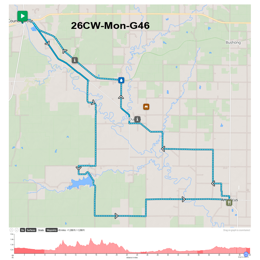
Notes on Monday Gravel Routes
There are two gravel routes for Monday – 40 and 46 miles. Both will use the Flint Hills Nature Trail and both will pass Allegawaho Memorial Heritage Park on the Flint Hills Nature Trail. The short route goes to the SAG at Basecamp Flint Hills in Allen, KS and back. The SAG for the long route will be in Americus.
Short Route – 40 Miles
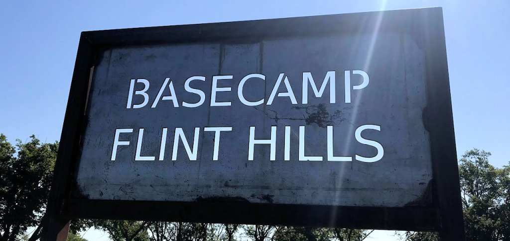
The short route takes the Flint Hills Nature Trail to Basecamp Flint Hills at Allen and back. The trail is well maintained and consists of packed crushed limestone. Under normal conditions a road bike can navigate the trail easily. So even if you didn’t bring your gravel bike you should still be able to ride the trail to Allen and back.
This may not sound like a short route, but it is only about 20 miles to Allen from Council Grove on the Flint Hills Nature Trail. Allow at least two hours to reach Allen and another two to get back after the SAG stop. If you leave CG by at least 8 AM you should be back in CG by 12:30 pm.
The good news is it is mostly downhill on the return trip.
Long Route – 46 Miles
This route will head southeast out of Council Grove on paved Dunlap Rd for about 5 miles then turn south onto gravel at 400 Rd to reach Lake Kahola in about 7 miles.
This reservoir was built in 1937 to supply water to Emporia and is situated on an area that was once part of the Kansa Indian Reservation. The old Indian treaty boundary runs across the southern edge of the lake.
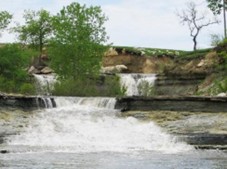
The border of Morris County to the north and Chase County to the south runs right down the middle of the lake from west to east. Below the dam to the east is a series of waterfalls created by the spillway. These may be viewed by continuing east of the dam on Kahola Rd. (Remember to return and cross the dam.) The lake is now privately owned by the Kahola Lake Community homeowner’s association. Direct access to the falls requires special permission from the HOA so you’ll have to stay on the road.
After crossing the dam and heading south for about 2 miles on Z Rd, the route then turns east on 290 Rd and heads toward Americus. At Americus there will be a SAG stop or you can self-SAG at Casey’s.
Leaving north out of Americus, the route goes to the ghost town of Dunlap. At Dunlap you will be on pavement as you travel northwest for a little over a mile and then north on gravel again at 200 Rd. This will hook up with the Flint Hills Nature Trail where there will be a water stop. From there go west on the FHNT back to Council Grove. During this section you will pass by Allegawaho Memorial Heritage Park.
History Along the Routes
Allegawaho Memorial Heritage Park
At about 4 miles east from Council Grove on the Flint Hills Nature Trail, you will come across the Allegawaho Memorial Heritage Park at the intersection of the FHNT and 525 Rd. The site marks the last Kaw (Kanza) Indian Village in Kansas prior to forced removal of the tribe to Oklahoma in 1873.
Give yourself some time to explore the area, which includes the remains of the Government Indian Agent’s home, the Monument to the Unknown Kanza Warrior on the hill, and large emblems of the Kaw Nation stationed along the hiking trail in the park.
The 158-acre Kaw Heritage Park is now owned and managed by the Kaw Nation from their offices in Oklahoma. The tribe has been making improvements to the site including a pavilion and visitor’s center.
History of the Sacred Rock
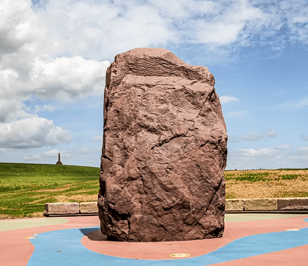
Also on display at the park is a massive red Sioux Quartzite boulder that holds deep historical, cultural, and spiritual meaning to the Kaw Nation.
The rock, known in geologic terms as an “erratic,” is believed to have been carved out during the ice age by a glacier from an area near the intersection of Minnesota, South Dakota, and Iowa.
As the glacier advanced, it pushed the rock south. When the glacier receded, the boulder was deposited at what is now the confluence of the Kansas River and Shunganunga Creek near Topeka.
The Kaw undoubtedly knew the rock was not native to the region and that it was very special. They held spiritual gatherings near the rock for hundreds of years before white men came. Then during westward expansion, the rock would become a landmark for settlers and travelers moving up the Kansas River valley.
However, in 1929 the stone was taken by organizers from Lawrence and moved to a small park overlooking the Kansas River to commemorate the 75th anniversary of the city and as a tribute to the abolitionist founders of Lawrence. In 2021 the city of Lawrence formerly apologized to the Kaw Nation for taking the rock and the massive stone was moved to Allegawaho Heritage Memorial Park in 2024.
More info on the Park:
http://www.kansastravel.org/allegawahopark.htm
https://footprints.com/blogs/take-a-walk-with-birkenstock/allegawaho-heritage-memorial-park-kaw-nation-kansas
More info on the Sacred Rock:
https://lawrenceskstimes.com/2024/04/02/sacred-red-rock-at-council-grove/
https://sacredredrock.com/about-us/
https://www.kcur.org/news/2024-06-26/kaw-kanza-sacred-rock-lawrence-kansas-flint-hills-monument-tribe
History of Dunlap
Dunlap was founded in 1869 by Joseph Dunlap, an Indian agent for the Kanza tribe. The town was situated on the Missouri, Kansas & Texas Railway (MKT) also referred to as the KATY.
In March 1874, a post office was opened, and the town was first called Hillsborough. The very next month, the name was changed to Dunlap. A man named Leonard Still established the first store in August which was just the third building erected in the town. The settlement then began to grow, and in 1875, it was incorporated.
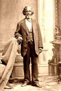
In the spring of 1878, Benjamin “Pap” Singleton, a former slave who escaped to freedom in 1846, chose Dunlap as a place to relocate numerous freedmen known as “Exodusters.” In May, the freedmen came by the hundreds from the post-Reconstruction South to seek homesteads in what was called the Singleton Dunlap Farm Colony.
In the beginning, African-Americans were forced to attend different schools and have their own churches and cemetery. In 1880, the Presbyterian Church founded the Freedmen’s Academy of Kansas in Dunlap to provide an education to African-American settlers. In 1882 the Academy served 90 male and 85 female students, of whom 45 were listed as ex-slaves.
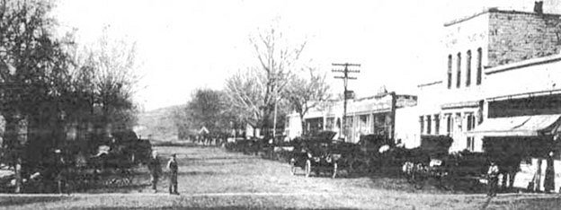
Dunlap’s population peaked in 1890 with 408 residents. In the early years of the 20th century, Dunlap experienced a building boom. A large attractive stone city hall was built on Main Street, and two new brick schools, a grade school and a four-year high school, were constructed. During the 1910s Dunlap had a department store, grocery store, a Farmers Union Co-op, drug store, an opera house, a funeral parlor, restaurants, a blacksmith shop, a car dealership, two filling stations, two banks, a livery barn, a mercantile company, and a hotel for visitors arriving at the KATY Depot.
By 1910, the population of the town was about 333 and its location on the Neosho River, in the midst of rich agricultural land, made the community an important shipping point for portions of Morris, Chase, and Lyon Counties.
After World War I, black children began attending integrated schools in Dunlap, and segregation subsided long before it did in the rest of the country. In 1920 there were two black churches and several white churches. A stone quarry was nearby, and regular passengers and freight traveled along the railroad, providing a demand for labor and shipping.
During the Great Depression the town began to decline, and its bank failed. Afterward, people began to leave the community to search for jobs in larger cities. Numerous floods from the Neosho River also put a strain on the community and the population dropped to 219 by 1940.
The KATY Railroad ended its passenger traffic through Dunlap in 1952, eventually tearing up their tracks in 1957. By 1960, the population had dropped to 134. The high school closed in 1962, and the grade school, damaged by a storm that ripped off its roof, closed in 1978. In the meantime, the buildings along Main Street were torn down, and now nothing remains. The high school was torn down somewhere along the line, but the 1918 gymnasium remains, which is maintained by the Volunteer Fire Department. The Dunlap post office closed in 1988.
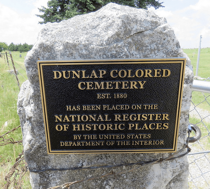
African-American Cemetery at Dunlap
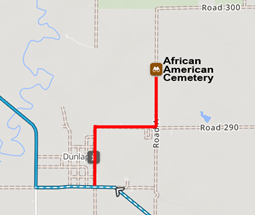
If you have the time and the roads are dry, take Broadway St. north through Dunlap to 1st St. going east and then left on Rd A to find the African American cemetery in about a half mile. This is on a dirt road so if it is wet it will be muddy.
The last black resident in Dunlap, London A. Harness, died on April 27, 1993, and was the last person to be buried in Dunlap African American cemetery, which is listed on the National Register of Historic Places.
The earliest burials in the cemetery date to 1880. Some of the oldest headstones are merely simple rocks in the ground.